


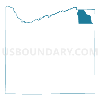
Voting District 110002, Cattaraugus County, New York
About
Outline

Summary
| Unique Area Identifier | 625698 |
| Name | Voting District 110002 |
| County | Cattaraugus County |
| State | New York |
| Area (square miles) | 25.61 |
| Land Area (square miles) | 25.42 |
| Water Area (square miles) | 0.19 |
| % of Land Area | 99.27 |
| % of Water Area | 0.73 |
| Latitude of the Internal Point | 42.47206630 |
| Longtitude of the Internal Point | -78.39597590 |
Maps

Graphs
Select a template below for downloading or customizing gragh for Voting District 110002, Cattaraugus County, New York


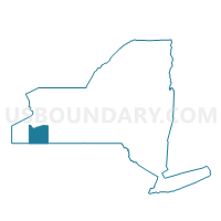
Neighbors
Neighoring Voting District (by Name) Neighboring Voting District on the Map
- Voting District 010001, Wyoming County, NY
- Voting District 010003, Wyoming County, NY
- Voting District 090001, Cattaraugus County, NY
- Voting District 110001, Cattaraugus County, NY
- Voting District 190001, Cattaraugus County, NY
- Voting District 340002 340003, Cattaraugus County, NY
Top 10 Neighboring County Subdivision (by Population) Neighboring County Subdivision on the Map
- Arcade town, Wyoming County, NY (4,205)
- Yorkshire town, Cattaraugus County, NY (3,913)
- Freedom town, Cattaraugus County, NY (2,405)
- Machias town, Cattaraugus County, NY (2,375)
- Farmersville town, Cattaraugus County, NY (1,090)
Top 10 Neighboring Place (by Population) Neighboring Place on the Map
Top 10 Neighboring Unified School District (by Population) Neighboring Unified School District on the Map
- Yorkshire-Pioneer Central School District, NY (16,029)
- Cuba-Rushford Central School District, NY (6,402)